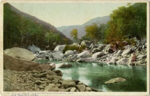
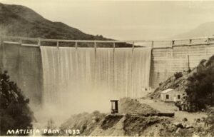
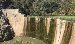
 The Matilija Dam, originally constructed in 1947, has outlived its usefulness. Matilija Lake has been replaced by approximately 9 million cubic yards of sediment, and the condition of the dam Concrete has deteriorated, therefore it no longer serves the purpose of providing water supply and flood protection to the community and planning efforts to safely remove it are in progress.
The Matilija Dam Ecosystem Restoration Project has many elements leading up to eventual dam removal, providing many benefits.
- Habitat Restoration
- Restore access for endangered Southern Steelhead trout to headwater spawning grounds, more than doubling river access and upstream habitat
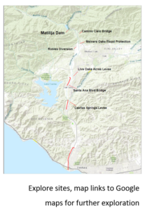
- New Camino Cielo bridge will increase safety for pedestrians and vehicles, while improving fish passage and sediment transport
- Live Oak Acres Levee and Casitas Springs Levee reconstruction will bring the levees up to FEMA flood control standards
- Newly constructed Santa Ana Blvd Bridge widened the riverbed to improve fish passage and sediment transport
- Robles Diversion modification to preserve water supply and fish passage while restoring sediment transport
- Meiners Oaks Flood Protection will enhance flood protection for the community
- Matilija Dam removal will support natural beach replenishment
- Various improvements will provide expanded recreational opportunities
- Along with addressing aged infrastructure, the project will provide jobs and an economic benefit to the community
Environmental Impact – At the end of 2023, a reissued Notice of Preparation of a Matilija Dam Ecosystem Restoration Project Subsequent Environmental Impact Report (SEIR) focusing on dam removal in compliance with the California Environmental Quality Act (CEQA) was published and a public scoping meeting held. Since that time Ventura County Watershed Protection District staff and their consultant have been working on the SEIR. Several previously unanticipated potential environmental impacts have been identified (e.g., marine and groundwater effects) that require detailed technical studies to inform the analysis in the SEIR. Once these and other technical matters are resolved, the Public Draft SEIR for dam removal will be released for public comment. Other SEIRs are in preparation for the Live Oak Acres Levee and Casitas Springs Levee Improvements.
The MDERP Story Map is an interactive GIS exploration of the locations and history of the Matilija Dam and MDERP. Click here to discover more.
For further information please see MatilijaDam.venturacounty.gov
Questions or comments? Email MDERP@venturacounty.gov.
