July 25th, 2025
Santa Paula Times
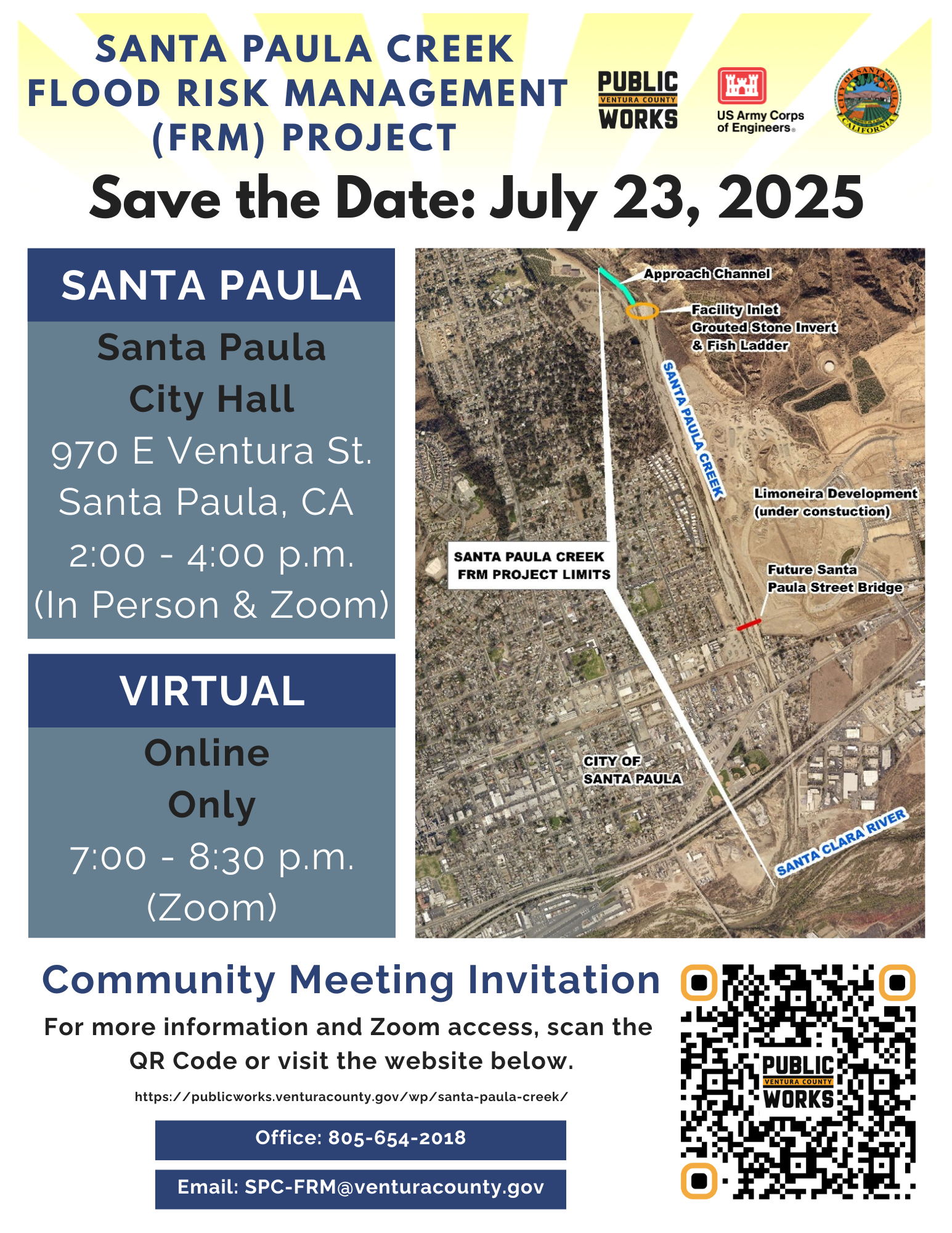
Those often-buffeted residents living along the Santa Paula Creek will especially want to attend a special scoping meeting to be held in person and on Zoom on Wednesday, July 23 staged by the county of Ventura government to address a fix for the at-times raging waters.
The meeting will be at Santa Paula City Council Chambers, 970 E. Ventura St., Santa Paula.
In-person and on Zoom
• Meeting 1 – 2-4 p.m. at the Santa Paula City Council Chambers, 970 E. Ventura St., Santa Paula
Join via Zoom at: https://us02web.zoom. us/j/81588526558
• Meeting 2 – 7-8:30 p.m.
online only
Join us via Zoom at https://us02web.zoom.us/j/81263578042
Comments also will be accepted up to to Aug. 10 , and may be submitted electronically to: cespl-santa-paula-creek@usace.army.mil or in writing to:
Brian McDowell,
U.S. Army Corps of Engineers,
Los Angeles District,
Planning Division,
915 Wilshire Blvd.,
14th Floor,
Los Angeles, CA 90017
The Ventura County Public Works Agency-Watershed Protection District, in cooperation with the U.S. Army Corps of Engineers and the city of Santa Paula, will hold two early public scoping meetings for the Santa Paula Creek Flood Risk Management Project. The creek is tributary to the Santa Clara River located along the east side of the city of Santa Paula.
These meetings will provide opportunities for early public engagement pursuant to the National Environmental Policy Act and the California
Environmental Quality Act.
“We welcome everyone,” noted the Ventura County Public Works Agency-Water Protection District press release, “and hope to see residents, tribes, businesses, nonprofit organizations, and fish and wildlife protection agencies among the participants.”
Santa Paula Creek Flood Risk Management Project Study Overview can be viewed online at:https://tinyurl.com/yr5388fj
Project history:
Between 1973 and 2002, the U.S. Army Corps of Engineers (USACE) built two different projects in the same location. In 1974, they completed Phase I of the first project, which included a concrete channel. A court stopped construction of the final two phases in 1975. The unconstructed Phases II and III would have extended the concrete channel further north and added two debris basins to help with flooding.
Project Changes & Updates
In the 1990s, U.S. Army Corps of Engineers began new planning and created a report to review and improve the project. From 1996– 2002, they studied environmental effects, planned updates, and constructed the new flood control channel. This included:
• Removing the concrete
channel.
• Making the creek wider and deeper to hold more water.
• Adding stone walls to an earthen channel bottom, adding a fish ladder, and improving three bridges.
New Data
In 2011, updated storm records showed bigger floods are now expected – about 39,400 cfs. This means some areas may still flood and have higher insurance costs. FEMA changed local flood maps in 2025, adding higher-risk zones in Santa Paula.
New Planning
U.S. Army Corp of Engineers got $200,000 in 2024 to start a new study for future improvements. The study will look at ways to protect areas still in danger of flooding. The study will also find out if there is a way to change the channel to trap less mud, rock, and debris.
Information on meetings
WHEN: Wednesday, July 23
2 to 4 p.m. (In-Person and Zoom)
7 to 8:30 p.m. (Zoom only)
WHERE: Santa Paula City Hall City Council Chambers, 970 E. Ventura St., Santa Paula, CA 93060.
WHY: The purpose of these early public scoping meetings is to gather input to best inform the study scope, formulate measures and alternatives, and evaluate potential environmental impacts associated with proposed alternatives. Both meetings will cover the same material, and virtual attendance for each meeting will be accessible via the project web site:https://publicworks.venturacounty.gov/wp/santa-paula-creek/.
DETAILS: The Project was initially authorized in 1992 pursuant to Section 203 of the 1948 Flood Control Act (Public Law (P.L.) 80-858), with subsequent authority through the Water Resources Development Act 1992, Section 114(b). Flood control channel construction in 2002 reduced the probability and consequences of flood related damages to the community of Santa Paula and surrounding areas.
Because the Project now has diminished flood control capacity,
which increases flood risk within the community, the Project is
undergoing general re-evaluation under Section 216 of the 1970
Flood Control Act (P.L. 91-611), which authorizes the secretary
of the Army to review operations of completed projects due to
changed physical, economic, or environmental conditions.
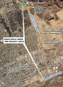
The Santa Paula Creek Flood Risk Management Project starts at the north side of Santa Paula and runs 1.65 miles through the east side of the city. It passes under the railroad bridge, Telegraph Road, and Highway 126 before joining the Santa Clara River. The lead Federal Agency for this study is the U.S. Army Corps of Engineers, Los Angeles District. The non-Federal sponsor for this study is the Ventura County Watershed Protection District in coordination with the city of Santa Paula.