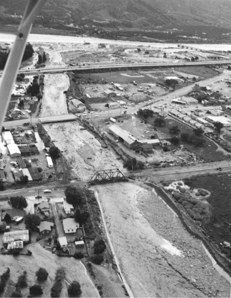
1969 Flood Event
Santa Paula Creek
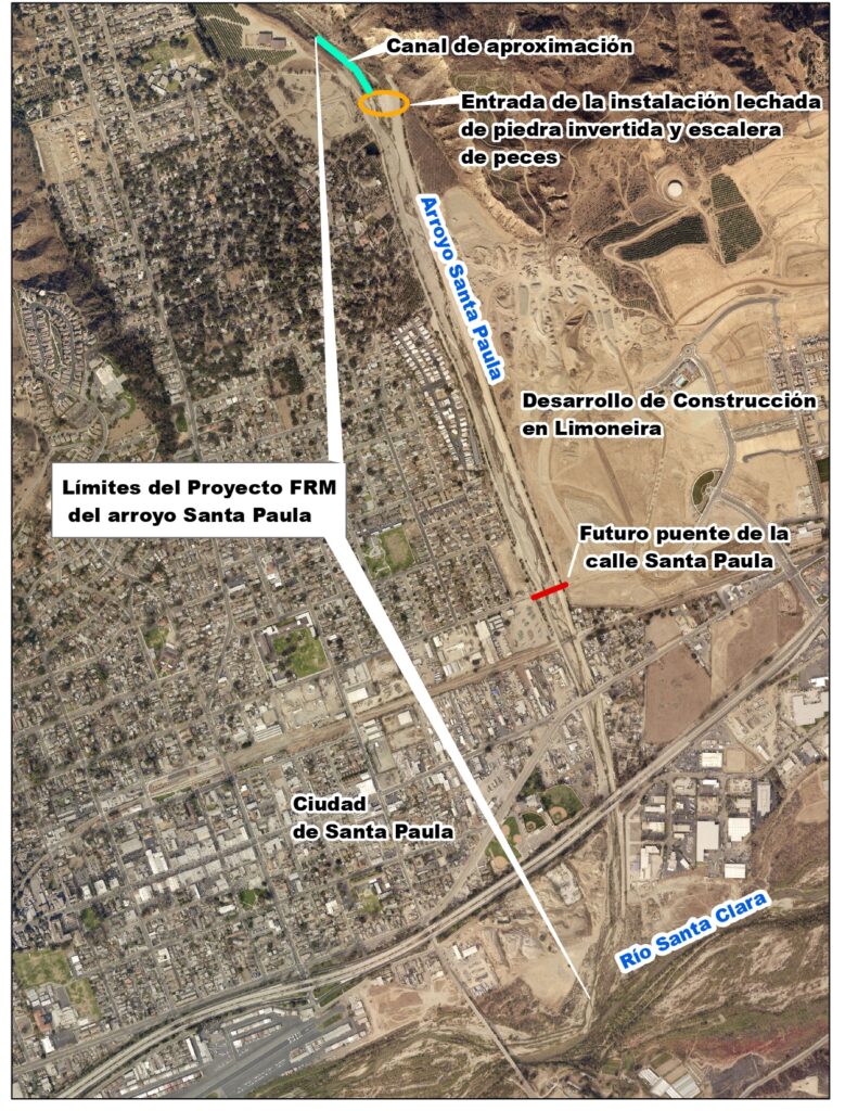
Santa Paula Creek Flood Risk Management Project

Major Storms
A big storm in January 2005 brought very high water (27,500 cubic feet per second), close to the system’s maximum capacity (28,000 cfs). It also filled parts of the channel with mud, rock, and debris, so it could hold less storm water. The storm damaged parts of the channel and fish ladder.
Big storms in January 2023 dumped more mud, rock, and debris. Less room for storm water caused flooding and damage at the south end of the system.
Maintenance Work
From 2009 to 2010, USACE fixed the fish ladder and cleaned out lots of mud, rock, and debris so it could hold more water again during the next storm. They worked with wildlife protection agencies and biologists to make sure animals like fish were protected.
In 2023 and 2024, Ventura County Public Works Agency-Watershed Protection cleaned out more mud, rock and debris so the channel would be ready for future storm flows again.
New Data
In 2011, updated storm records showed bigger floods are now expected – about 39,400 cfs. This means some areas may still flood and have higher insurance costs. FEMA changed local flood maps in 2025, adding higher-risk zones in Santa Paula.
New Planning
USACE got $200,000 in 2024 to start a new study for future improvements. The study will look at ways to protect areas still in danger of flooding. The study will also find out if there is a way to change the channel to trap less mud, rock, and debris.
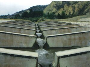
Fish Ladder in 2002
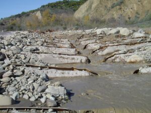
Fish Ladder After Storm Damage
Opportunities
- Enhance facility function and environmental quality through incorporation of Natural and Nature Based Infrastructure.
space - Restore native vegetation and remove invasive and fire prone vegetation. Provide recommendations for land management strategies that reduce fire risks.
space - Consider more effective and resilient designs/repairs to the existing fish ladder, or eliminating the need for a fish ladder altogether.
space - Incorporate traditional knowledge and uses of native species.
space - Address potential Operations and Maintenance challenges.
space - Incorporate recreation features and interpretive signage that describe project features (i.e. fish ladder importance to endangered species).
space - Increase groundwater recharge potential.
Detailed Project Information
The Santa Paula Creek Flood Risk Management (FRM) Project begins at the northern boundary of the City of Santa Paula and traverses 1.65 miles south through the eastern part of the city, below the Ventura County Transportation Commission railroad, Telegraph Road, and State Highway 126 bridges, and finally joins the Santa Clara River.
Between 1973 and 2002, the U.S. Army Corps of Engineers (USACE) constructed the Santa Paula Creek FRM Project through a local cooperative agreement named FC-2-7311A. In 1974, USACE completed the first of three phases of the FRM project in Santa Paula Creek (Phase I). The authorized project consisted of a concrete-lined channel and debris basins on Santa Paula Creek and Mud Creek, a tributary of Santa Paula Creek. A 1975 court injunction prevented construction of the remaining two phases.
USACE resumed project planning in the mid-1990’s, resulting in the preparation of a General Reevaluation Report (GRR) to assess the condition of the existing facility and to evaluate a range of alternatives to provide flood protection in Santa Paula. From 1996 through 2002, a joint Environmental Impact Statement and Environmental Impact Report was prepared and certified for the GRR-revised FRM project. The revised project consisted of the removal of the Phase I-authorized concrete channel, improvement of creek capacity through excavation within the channel and right-of-way, grouted stone side slope protection along the excavated trapezoidal channel, a grouted stone inlet, future periodic debris removal, a railroad bridge modification, a channel transition from trapezoidal to vertical concrete walls upstream from the Telegraph Road bridge, and the construction of a fish passage structure at the project inlet. During storms on January 10-11, 2005, the Santa Paula Creek FRM Facility experienced extreme peak flows of 27,500 cfs, coinciding with the 1990s project’s designed peak flow capacity of 28,000 cfs during a one percent annual chance flood. These high flows damaged the fish ladder, deposited excessive sediment at the downstream end of the channel, and eroded a portion of the upstream end of the channel.
In 2009-2010, USACE restored function of the fish ladder, removed 350,000 cubic yards of accumulated sediment from the lower channel, and worked with the National Marine Fisheries Service (NMFS) to obtain a Jeopardy Biological Opinion (BO) with accompanying Reasonable and Prudent Alternatives. NMFS issued a second Jeopardy BO in July 2020. USACE obtained a Biological Opinion from the U.S. Fish and Wildlife Service in February 2024. The consultations will support USACE’s delivery of a final draft Operations, Maintenance, Repair, Rehabilitation & Replacement Manual to allow for the full transfer of the project to Public Works Agency-Watershed Protection for maintenance.
Also, during this period, USACE certified a new and updated hydrology report for the Santa Clara River watershed, including Santa Paula Creek in 2011. This report included an additional 25 years of storm records which resulted in a 40 percent increase in peak flood flows to 39,400 cfs for a one percent annual chance flood. The expected peak flood flow increase renders the FRM Facility deficient in meeting the original design intent. Therefore, significant areas within the City of Santa Paula’s lower end will remain flood prone and potentially subjected to higher flood insurance cost increases. The Federal Emergency Management Agency revised City of Santa Paula Flood Insurance Rate Maps (FIRMs) on May 15, 2025 (https://www.spcity.org/DocumentCenter/View/5604/SantaPaula-Mapping-FactSheet). The revised maps eliminated the previously mapped A99 Flood Hazard designation and add an AE High Hazard Risk designation to some City areas.
